Operated by University of Southern California, Civil Engineering Department, Strong Motion Research Group
Contact: Prof. Mihailo D. Trifunac, E-mail: trifunac@usc.edu; (213) 740-0570; Prof. Maria I. Todorovska, E-mail: mtodorov@usc.edu
Background
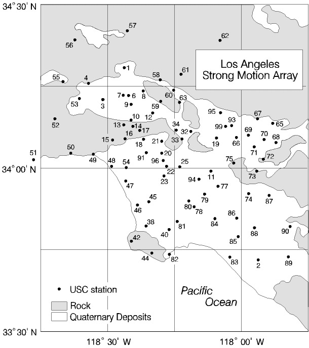
The Los Angeles and Vicinity Strong Motion Network has 80 stations spread throughout the metropolitan area, each recording three components of ground acceleration in “free-field” conditions. The recording instruments are SMA-1 accelerographs. The array was planned and installed between 1978 and 1980 with financial support from the National Science Foundation. It became fully operational in the spring of 1980. The purpose of the array has been to record strong ground motion in the metropolitan area, to help understand and quantify the spatial distribution of strong shaking, the attenuation of strong motion amplitudes with distance, the effects of the geological structure and local soils on the strong motion amplitudes, and the relationship between strong ground shaking and damage to structures. The Strong Motion Recording Laboratory at USC was established in 1978 to support the activities of the array. This project is currently supported by a grant from the National Science Foundation (Principal Investigator: M. Todorovska).
The array represents a full-scale laboratory, of the size of a metropolitan area. Damaging urban earthquakes are rare events with significant consequences (earthquakes like the ML=6.4 Northridge can occur on the average about every 20 years, and the damage is of the order of billions of dollars). They also happen unexpectedly, both in time and in space. Therefore, repeated recording of significant ground motions during the life of an array is a success. The Los Angeles Strong Motion Network has been very fortunate in that respect. During the 18 years of operation, the array recorded many earthquakes of magnitude 3 and grater, including the Whittier-Narrows (1 October, 1987, M=5.9, 68 records), Sierra Madre (28 June, 1991, M=5.8, 65 records), Landers (28 June, 1992, M=7.5, 61 records) and Northridge (17 January, 1994, M=6.7, 65 records). The processed data is distributed by the National Geophysical Data Center (NGDC) of NOAA (National Oceanic and Atmospheric Administration, U.S. Department of Commerce, Boulder, Colorado) or can be downloaded from the internet (the Northridge earthquake data only, from USC web).
Northridge, 1994, Earthquake Records
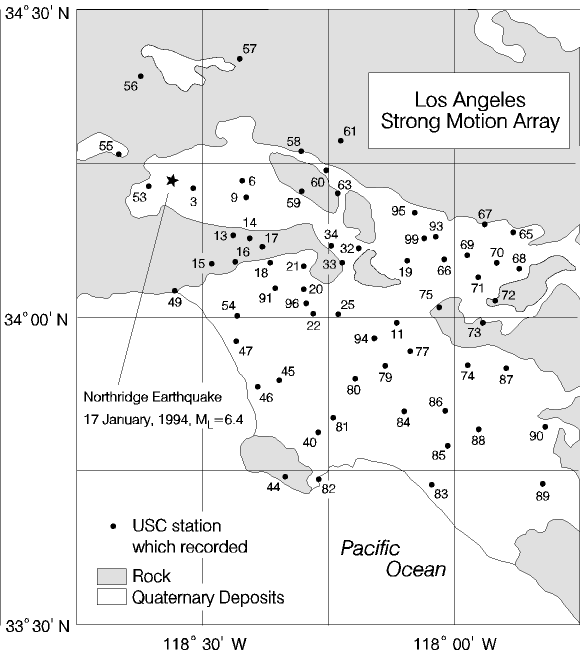
The Northridge earthquake of 17 January 1994 (ML=6.4) was recorded by 65 stations of the Los Angeles Strong Motion Array, at epicentral distances between 2 km and 85 km, and at various azimuths from the source. Eleven of the stations were at distances closer than 20 km, and 25 were at distances closer than 30 km from the epicenter. The recorded peak accelerations approached 1g at several stations. All but few of the stations are in the densely populated metropolitan area, and one is at Potrero Canyon where large ground movements were observed. The recordings are invaluable for studies of the fault mechanism, spatial distribution of ground shaking, nonlinear soil response and ground failure, and interpretation of damage to structures and lifelines.
The details of gathering and processing of the Northridge main event data are described in Trifunac et al. (1994) and Todorovska (1997). Funding for the data gathering and processing was provided by the US Geological Survey and the National Science Foundation (PI: Todorovska). Volume 1, 2 and 3 data (corrected acceleration, velocity, displacement and Fourier and Response Spectra) are available on the web from Center or Engineering Strong Motion Data.
The above figure shows the location of the recording stations, identified by the USC station numbers. Table 1 lists the stations, their location, geographical coordinates, epicentral distance, duration of the record and uncorrected peak acceleration for the three components of motion, determined from digitized data. The records were digitized by a PC system with a flat-bed scanner and processed with standard data processing software (Lee and Trifunac, 1990). Stations USC 03 and 53 were the closest strong motion stations to the epicenter, and USC 91 was the closest strong motion station to the collapsed La Cienega-Venice and Fairfax-Washington under-crossings of Interstate 10.
The USC stations are installed mostly in one story buildings (exception is USC 96). The site condition parameters (geologic site condition parameter, local soil condition parameter and the A, B, C and D classification, based on the average shear wave velocity in the top 30 m of soil) for the recording stations are discussed in Trifunac et al. (1994) and Trifunac and Todorovska (1996).
Summary of Processed Earthquake Records
| No. | Earthquake Name | Date and time (GMT) | M | H km |
Stations |
|---|---|---|---|---|---|
| 1 | Santa Barbara Island | 09/04/1981 15:50 | 5.5 | 5 | 7 |
| 2 | North Palm Springs | 07/08/1986 09:20 | 5.9 | 10 | 15 |
| 3 | Oceanside | 07/13/1986 13:47 | 5.3 | 9 | 6 |
| 4 | Whittier-Narrows | 10/01/1997 14:42 | 5.9 | 14 | 68 |
| 5 | Whittier-Narrows aft. (1) | 10/01/1997 14:43 | 3.8 | 15 | 16 |
| 6 | Whittier-Narrows aft. (2) | 10/01/1997 | 1 | ||
| 7 | Whittier-Narrows aft. (3) | 10/01/1997 14:45 | 4.4 | 14 | 33 |
| 8 | Whittier-Narrows aft. (4) | 10/01/1997 14:48 | 3.5 | 14 | 3 |
| 9 | Whittier-Narrows aft. (5) | 10/01/1997 14:49 | 3.9 | 13 | 41 |
| 10 | Whittier-Narrows aft. (6) | 10/01/1997 14:51 | 3.1 | 15 | 3 |
| 11 | Whittier-Narrows aft. (7) | 10/01/1997 15:12 | 4.0 | 15 | 35 |
| 12 | Whittier-Narrows aft. (8) | 10/01/1997 15:17 | 3.3 | 15 | 2 |
| 13 | Whittier-Narrows aft. (9) | 10/01/1997 15:59 | 3.8 | 15 | 12 |
| 14 | Whittier-Narrows aft. (10) | 10/01/1997 16:21 | 3.3 | 16 | 2 |
| 15 | Whittier-Narrows aft. (11) | 10/01/1997 19:11 | 3.4 | 15 | 1 |
| 16 | Whittier-Narrows aft. (12) | 10/04/1997 10:59 | 5.3 | 13 | 60 |
| 17 | Whittier-Narrows aft. (13) | 02/11/1998 15:25 | 4.7 | 17 | 37 |
| 18 | Sierra Madre | 06/28/1991 14:43 | 5.8 | 12 | 65 |
| 19 | Landers | 06/28/1992 11:57 | 7.5 | 5 | 61 |
| 20 | Big Bear | 06/28/1992 15:05 | 6.5 | 5 | 50 |
| 21 | Northridge | 01/17/1994 | 6.7 | 18 | 65 |
| 22 | Northridge aftershocks | 01/17/1994 to 03/23/1994 | >5 | 115 |
Data distribution:
Center or Engineering Strong Motion Data
http://www.strongmotioncenter.org/
Contact